A Mountain Photography Expedition to Everest and the Remote Gokyo Valley
This image represents one of the goals of our mountain photography expedition, the view of Everest from above Gokyo village. Our Himalayan journey took place during Covid, but because we were working on a film project that the Government of Nepal thought was good for the country, we were granted special access to the Everest Valley. We were a few of the less than 10 westerners in the whole region. Always on the lookout for unusual adventures, we began our trekking journey from the village of Goli, which was the starting point for Edmund Hillary and Tenzing Norgay’s 1953 expedition which put the first two people on the top of the world. This added four extra days to the modern Everest Basecamp Trek and A LOT of extra vertical feet of climbing. After reaching Everest Basecamp we turned left and climbed over the 17,700 foot Cho La (la means pass) and into the Ngozumpa Glacier drainage. We then trekked up to Gokyo village and a little beyond to this vantage point. If you’d like to watch a video about this journey you can go to Youtube here. But for now let’s start at the beginning, Kathmandu.

A Shrine to the Goddess Kali

Boudanath Temple in Kathmandu
The Goddess, Kali the Destroyer, presides over Durbar Square in Kathmandu. Durbar Square is part of the ancient city and the location of the old royal palace. Thousands of people come here every day to pray and make offerings to Kali. From destruction comes rebirth. I used a slow shutter speed to blur the movement of the people in this image in order to emphasize the feeling of busy-ness and chaos that is Kathmandu. If you’ve never been to Kathmandu, Mumbai or a similar third-world city then you cannot imagine the crowding and mayhem that is life there. It is an absolutely engrossing place for Nepal travel photography.

The view from Pee-kay Peak

Drinking with the locals
After a truly arduous, lurching 13-hour jeep ride from Kathmandu over terrible roads our trekking began in the village of Goli. These days almost all Everest trekkers fly into the village of Lukla and walk from there, but we wanted to visit areas, and find unique mountain photography locations that are now rarely visited by westerners. On day two we made it to the top of Pike (pronounced pee-kay) Peak, and a short distance below the summit was this little teashop (or should I say bar?). In this travel photography image, Nepalis on vacation are drinking rakshi, a rice wine, and having great fun. In our culture could we sit on hard wooden benches in a cold smoky hut, drinking home-made wine and claim we were having a good time? (Maybe we don’t have it all figured out). We joined in for the rakshi and fun. To experience Nepal without other westerners is exactly why we took this route.


After Taksindo we descended into the Khumbu Valley which leads one up to Sagarmatha (Everest). This photo shows typical trekking terrain at the lower elevations: very steep valleys carved out by rivers. Further up, and closer to the highest peaks, the terrain is easier due to ancient glacial scouring.
Two days later we arrived in the beautiful and peaceful hillside village of Taksindo, far from the tourist trail. This lovely monastery is home to a vibrant community of lamas (monks) and the head lama was kind enough to meet with us and lead our group in a meditation.


These are Mani Stones and they are everywhere along the Everest trail. The mantra Om Mani Padme Hum is carved into the rock. By etching the mantra into the stones the carver accrues merit that will lead to a better birth the next time around.
A spinning prayer wheel. The Khumbu Valley is a sacred place for the Sherpa people and prayer wheels are a very common site.

Further up the trail, and closer to Everest is a perch where one can look back down the way recently traveled. In this image afternoon clouds flow up the Khumbu Valley below 22,349 foot Ama Dablam. This is a wonderful mountain photography location and is the spot where there are many memorials to the dead climbers of Everest. The names of legends cover the land here. These were behind me while I was capturing this image. The first time I was here in 2000, I lingered in this spot after everyone else continued up the trail and could feel the presence of these great mountaineers.

At the head of the Khumbu Valley is the black pyramid of Everest. This photo was taken from one of the world’s greatest mountain photography locations, the hill called Kala Patthar (18, 500 feet). Down and to the left is the location of Everest Base Camp and on the right of the frame is Nuptse.

After leaving Kala Patthar we crossed the 17,700 foot Cho La (pass) and descended to the Ngozumpa Glacier, shown here. The glacier is about a mile wide and, as you can see, extremely rugged. As the glacier melts away, pyramids of ice covered with loose rubble are left behind. We crossed this icy, rocky landscape to get to the village of Gokyo at 15,584 feet. Traveling over this type of terrain can be quite slow.

Past Gokyo, further up the trail at a place called Fifth Lake, is this marvelous view of Sagarmatha (Everest), Mother Goddess of the World. This is another of the world’s great mountain photography locations. It’s harder to get to than Kala Patar as it requires camping overnight but, I believe, is a better view.

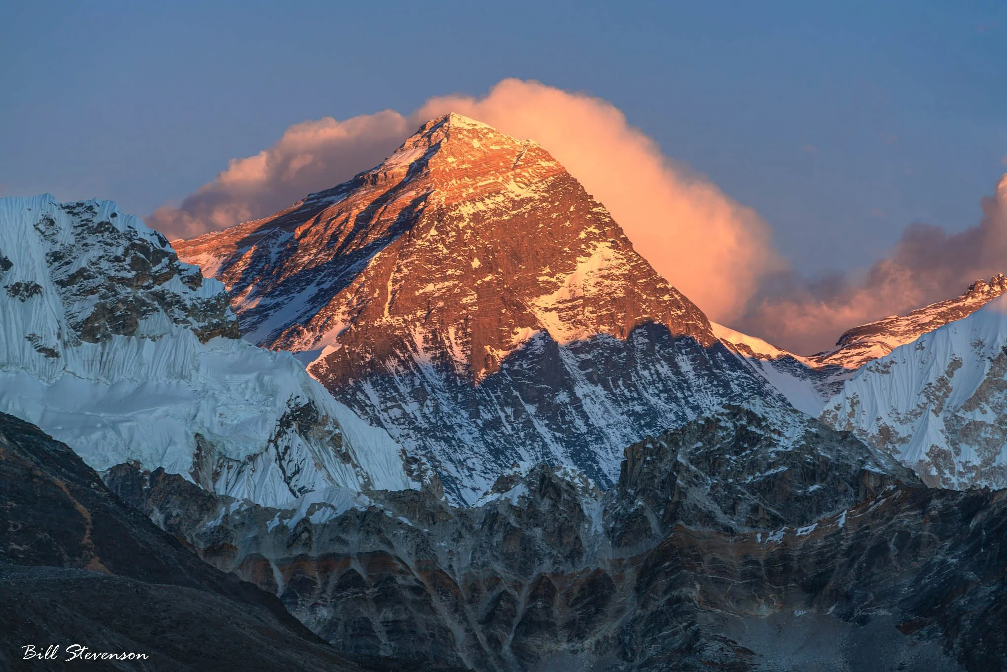
The Mother Goddess of the World again, from the same location, as sunset approaches. This image was captured in December at 17,000 feet and it was cold and windy but to stand there and watch the colors and shadows slowly change was an inspirational few moments.

Sagarmatha goes to sleep